top of page

My Services and Projects
Projects and Services: Welcome
Land Surveying
Conducting boundary surveys, topographic surveys, construction surveys, and cadastral surveys for various purposes such as land development, urban planning, or infrastructure projects.
Drone Mapping and Aerial Photography
Utilising drones to capture high-resolution aerial imagery for mapping, site monitoring, and environmental assessment.
Data Collection and Analysis
Collecting geospatial data using drones and other surveying equipment, and analyzing this data to provide insights for various applications such as agriculture, forestry, or disaster management.
GIS (Geographic Information System) Services:
Creating, managing, and analysing geospatial data in GIS software to generate maps, perform spatial analysis, and support decision-making processes in various industries including urban planning, natural resource management, and transportation.
Remote Sensing
Using remote sensing techniques to gather information about the Earth's surface from satellite or aerial platforms, and applying this data to assess environmental changes, monitor land use, or detect natural disasters.
3D Modeling and Visualisation
Generating digital terrain models (DTMs), digital surface models (DSMs), and 3D models of landscapes or infrastructure using surveying and drone data, and creating visualizations for project planning and communication purposes.
Consulting Services
Providing expertise and advice on surveying, geomatics, and drone technology to clients in various industries, helping them to leverage spatial data effectively for their projects and business operations.
Projects and Services: About
My Projects
Zimbabwe: Odyssey Through History and Beauty
The Earth is Crying Impact of Climate Change on Zimbabwe
Soil Moisture Mapping using remote sensing

Projects and Services: Services
My Projects
Informal Sector Taxation: Spatial Analysis
High-Resolution Hyperspectral Mapping of Secondary Sulfate Minerals for Acid Mine Drainage (AMD) Risk Assessment
Tree loss Analysis using data from Global Forest Watch
Projects and Services: Services
_edited_edited.jpg)
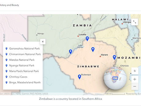
Zimbabwe: An odyssey through history and beauty
This is a story map showing historical places in Zimbabwe, National Parks and places to visit.
Projects and Services: Opening Hours


Population Distribution Map for West Africa


Projects and Services: Feature

This is a locality map for GreenFuel Chisumbanje.

Projects and Services: Team
bottom of page